
Discover the national and local distribution of every species of bat in Australia. Distribution maps have been developed by leading bat experts and are updated and maintained by utilising the collective knowledge of the members of the Australasian Bat Society.
Use the buttons below to explore the distributions of Australian bat species, obtain a bat species list for your area, or download species distribution maps in different formats.
BatMap Applications
BatMap Downloads
BatMap species distribution maps are free to download for ABS Members. Maps are also free to download for Non-ABS Members but are encouraged to donate to the ABS, particularly if the maps are being used for commercial purposes, or a funded project. All maps are licenced under Creative Commons.*
Maps are updated as any distribution changes occur. Advanced users can also access source maps directly via ArcGIS Online.
Some KMZ files will not display properly in Google Earth. Use an alternative KMZ viewer such as ArcGIS Earth or Google earth online.
Maps are updated as any distribution changes occur. Advanced users can also access source maps directly via ArcGIS Online.
Some KMZ files will not display properly in Google Earth. Use an alternative KMZ viewer such as ArcGIS Earth or Google earth online.
Distribution Categories
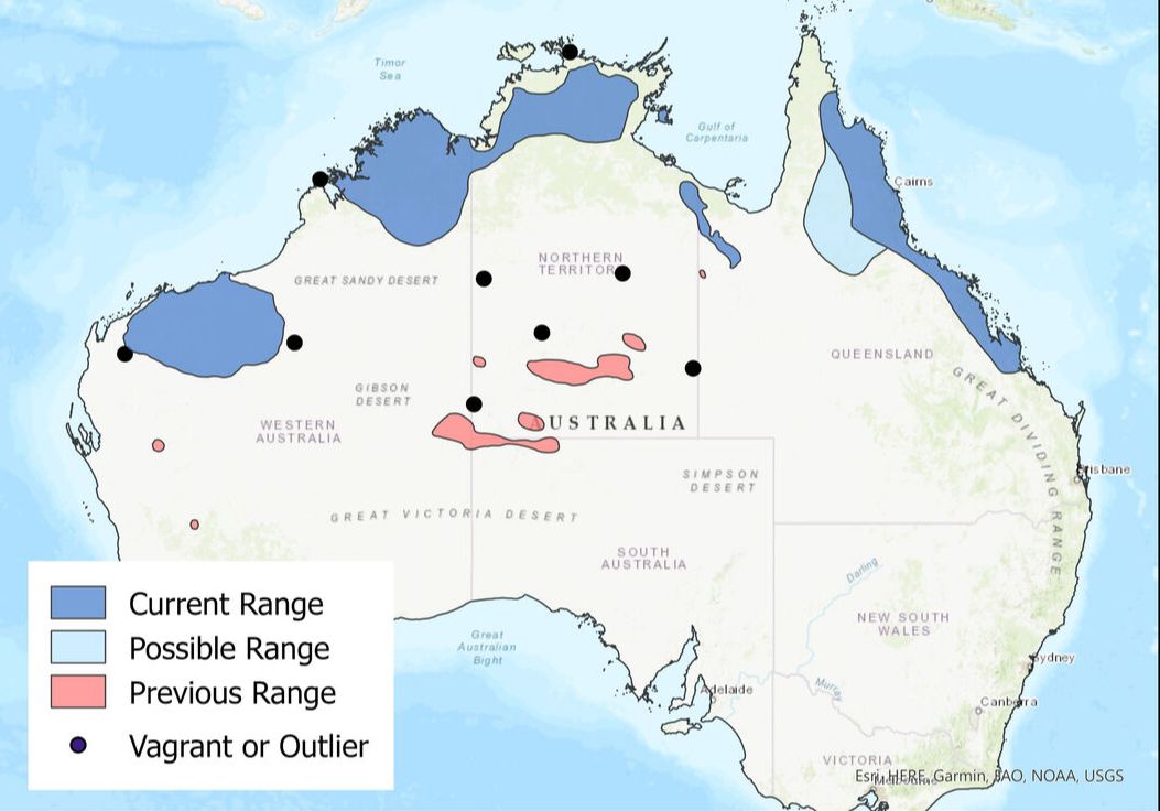
Where applicable, species distribution maps contain the following categories:
Current Range - area where the species is currently known or likely to occur. This is the area that you would typically see on a distribution map in a natural history publication.
Possible Range - area where the species may occur; however, it is uncertain that the species actually occurs there. Current records in these areas are doubtful.
Previous Range - area where the species was known to occur but there is now reasonable doubt that the species is extant in the area.
Extralimital Records - confirmed or known records of individuals of the species outside the current range.
More detailed descriptions of each of the distribution categories are provided here.
Species
Bat Species of Australasia is BatMap's sister project. Discover what bat species occur in each State and Territory of Australia as well as other regions within Australasia.
Map status
To see when individual species maps were updated click here.
Reliability & Accuracy
Distribution maps were based on the collective knowledge and experience of Australia’s bat experts. Experts also utilised other sources of information that was available to them such as unpublished literature and data. In some areas of Australia, highly reliable information was readily available. Distributions in those areas were based on objective opinion and, spatially, are relatively accurate. In other areas, information is sparse or non-existent. Unavoidably, therefore, distributions in those areas were based to some degree on the subjective opinion of experts, and the resulting accuracy and reliability of mapping in those areas are lower. Distribution maps are updated as new information becomes available; therefore, the overall reliability and accuracy of maps will improve over time.
Contribute to BatMap
If you think you have new information that you want to contribute to one or more of the species distributions maps, please email [email protected]. We will send you instructions how to contribute.
Citations and Credits
For individual species maps follow this example:
Australasian Bat Society - BatMap. Austronomus australis at http://ausbats.org.au/batmap. Accessed 21/04/2021.
For all species maps follow this example:
Australasian Bat Society - BatMap. http://ausbats.org.au/batmap. Accessed 21/04/2021.
The following publication is also available:
Milne Damian J., Reardon Terry B., Ford Greg (2023) BatMap – authoritative distribution maps for Australian bats. Australian Mammalogy. https://doi.org/10.1071/AM23005
A number of people were responsible for making BatMap happen. You can see who they are here.
* BatMap species distribution maps are licensed under a Creative Commons Attribution 4.0 International licence, which means you can do whatever you like with the maps, so long as you give appropriate credit, and indicate if you change the maps in any way.
